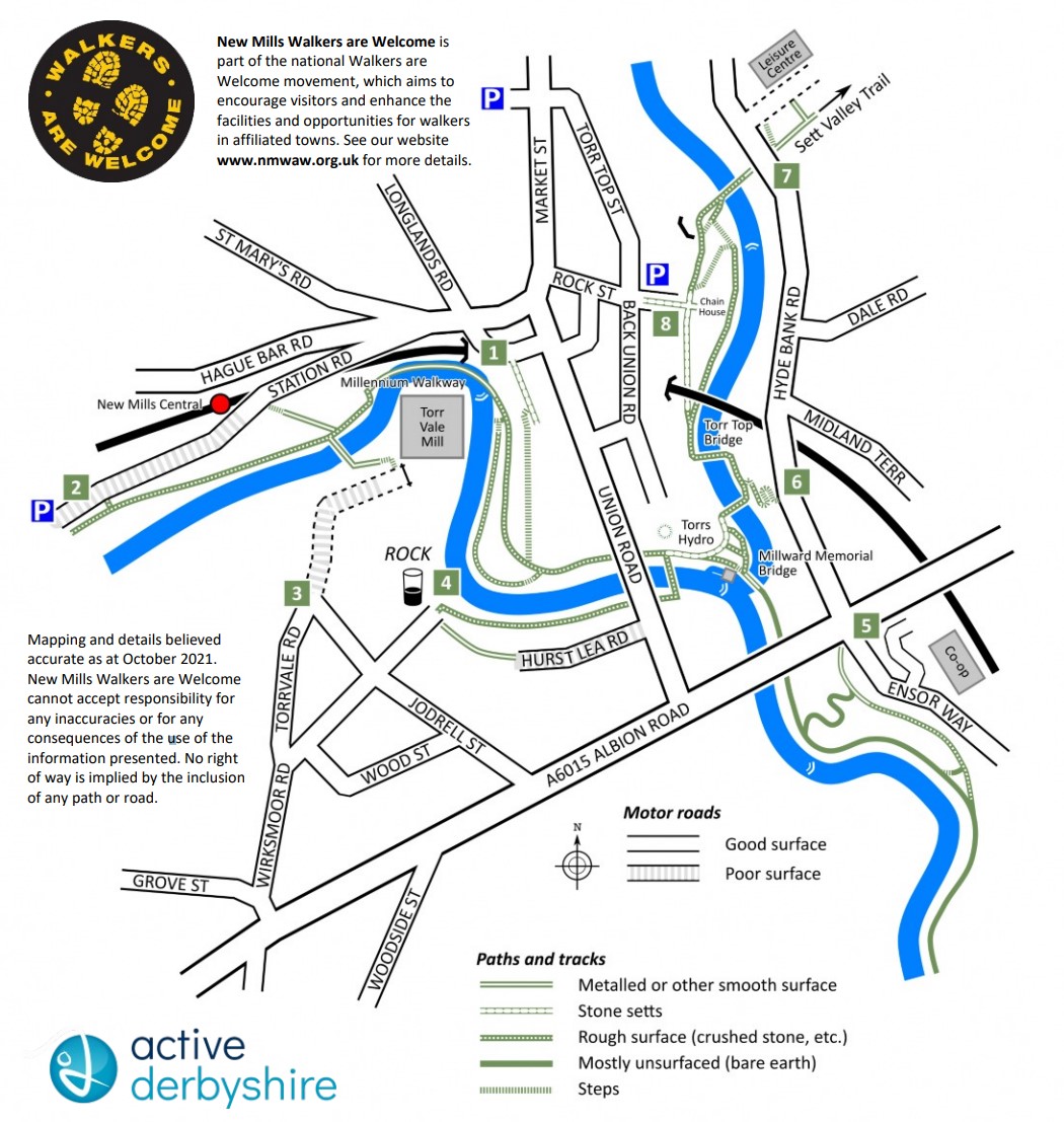
 Overview The Torrs sandstone gorge, which cuts through the centre of the town of New Mills, Derbyshire, is a geological feature of towering beauty which houses the Torrs Riverside Park (also called “the Park under the Town”), a delightful picnic area, Torrs Hydro (a community-owned hydroelectric scheme), and several elegant bridges, as well as substantial evidence of industrial heritage. Foremost amongst these treasures, the Millennium Walkway is a fine piece of modern engineering which finds itself abutting a substantial Victorian retaining wall and facing Torr Vale Mill. The mill had the longest continuous period of cotton manufacture of all the mills in the UK at 212 years.
Accessing all this beauty and heritage can be a challenge, however, as they are to be found at the bottom of the gorge, by the Rivers Goyt and Sett, and approximately 70 metres beneath the level of the roads. There are several access points, all of which can present separate challenges, but the effort will be rewarded with some breath-taking scenery to explore.
This Page/leaflet explores some of those access points with a view to helping you make your choice as to the most suitable way down for you. Leaflet produced by New Mills Walkers are Welcome.
Mobility Scooters Those visiting the Torrs using mobility scooters are advised to do so with great care and only in the company of others that can assist where necessary. This is particularly true of scooters with small wheels and low ground clearance as many of the slopes are not only steep but also rough and uneven. The most suitable routes down would be via 1 Station Road or 4 Hurst Lea Road (see below). All other routes either involve steps or are too steep. The river Goyt can be accessed by a track from Ensor Way next to the Co-op car park, but the route along the riverbank into the Torrs is narrow and uneven, with a short but steep drop to the water below
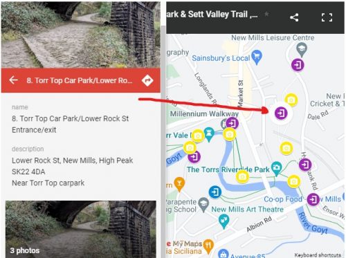
Please see interactive map, click on Icon![]() to see address for location and photos of the entrance/exit. As shown in the photo
to see address for location and photos of the entrance/exit. As shown in the photo
There are additional photos using this Icon ![]() , showing various, bridges, steps and locations that might affect accessibility.
, showing various, bridges, steps and locations that might affect accessibility.
There is another pictured map after the detailed information of each the access points below.
There are Accessible walks to other locations here: https://visitnewmills.co.uk/things-to-do/walks/disabled-access-walks/
1 Bus Station Steps/ Rock Mill Lane Entrance/exit
![]() ///appealing.pickles.panic
///appealing.pickles.panic
Here, the Torrs are at their highest point. The descent starts with a short-cobbled slope which leads down to a short but steep flight of steps. A short uneven track leads to another short flight of steep steps, and then there is a longer flight of shallow steps with extensive concrete treads. There is a solid handrail beside each flight of steps, which total 51 in number.
This access point lies closest to any bus stop as it begins within 10 metres of the bus station, down yet another (avoidable) flight of steps.
2 Station Road 2, Entrance/Exit
 ///asteroid.sticking.celebrate
The road leads down from Hague Bar Road past New Mills Central Station and on to Mouseley Bottom. At the bottom a track leads back along the river and into the Riverside Park over the Millennium Walkway. Station Road is a steep single track road which is unadopted beyond the station and whose surface has been allowed to deteriorate considerably. Parking spaces can very occasionally be found at the bottom it has a pay and display car-park and the track along the river is firm, wide and reasonably level.
New Mills Central Station lies midway down Station Road; as well as the lower road route, there is a direct, metalled footpath down to the river from the station, beginning with a flight of steep stone steps.
3 Torr Vale Mill/Road Entrance/Exit
///describe.fortnight.thrashed
Torr Vale Mill is accessed down Wirksmoor Road and Torrvale Road. The metalled road becomes a cinder track of good if muddy surface. As you approach the mill, the track narrows and here a
steep flight of steps leads down beside the mill, onto a narrow and dark path of slightly uneven surface. The track leads to a narrow footbridge over the river Goyt, from which the Millennium Walkway can be seen to the right. Turn right at the end of the bridge.
Public transport: the nearest bus stop is on Albion Road, a walk of approximately 250 yards.
4 Hurst Lea Road/Wirksmoor Rd Entrance/Exit
///email.searcher.coast
Walk down Union Road from the bus station. Turn right onto Hurst Lea Road just before the police station. The road has a metalled surface to begin with, but quickly becomes uneven. Halfway along, the surface improves when the track narrows to a metalled path. At the end of this path is the Rock pub and garage. Here, turn right and walk down the track which leads into the Torrs. This track has a
reasonably smooth surface, but, although the cliffs on the south side of the gorge are lower than those to the north, the gradient remains steep. This route can be negotiated with a pushchair and a little muscle power, though drainage gullies may be awkward to small-wheeled equipment.
5 Ensor Way/Co-op Supermarket/Church Rd, Entrance/exit
///advances.escalates.hatter
The advantage of this route is that it starts at the lowest point of all the access routes. A wide, surfaced track runs down beside Ensor Way, reaching the river Goyt at a bend. Here turn onto a much narrower track which can be quite muddy, and rendered uneven by exposed rocks and tree roots. About 200 yards along, this track follows a slight decline and turns onto the old leat which provides a smooth if muddy footing. Follow this track over the Millward Memorial Bridge into the Riverside Park.
Buses in both directions stop beside the bridge that crosses the river Goyt at the top of this route.
6 Hyde Bank Road Steps – Hyde bank Rd Entrance/exit
///medium.regaining.magic
As you walk along Hyde Bank Road, an opening 25 yards along on your left leads to a path down into the Torrs. Two switchback flights of concrete steps (which can be very slippery at any time, but particularly in autumn when the leaves have fallen) are followed by a track that leads to a stone bridge over the River Sett. The handrail by the steps is substantial, though non-existent when the route turns into the track.
7 Leisure Centre – New Mill leisure centre entrance/Exit
///soggy.waxing.skis
A flight of steps besides the bridge at the entrance to the leisure centre leads down onto a metalled path (these steps can be avoided via the rear of the leisure centre car park). Follow the path under the bridge and over the River Sett. Here a fairly level and accessible path continues via the tunnel mouth opposite to Lower Rock Street, below Torr Top Car Park (see below), or another flight of steps on the left leads down into the section of the Torrs on the River Sett. Torrs Hydro and the Millennium
Walkway can be reached from here via Torr Top Bridge, built to bypass a rockfall in 2016. The path and steps are firm and even, though often muddy.
8 Torr Top Car Park/Lower Rock St Entrance/exit
///hogs.mermaids.incensed
A steep cobbled path besides the car park (Lower Rock Street) leads down into the Torrs. The path splits partway down, the right-hand path continuing down and remaining steeply and unevenly cobbled and very slippery when wet. There is a sturdy handrail to assist. The left fork leads to a bend and steps down as per the Leisure Centre access (see above).